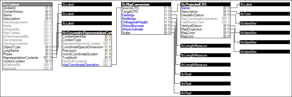
Figure 282 — Project Global Positioning
Adding a geospatial coordinate reference to the geometric representation context using a recognized coordinate reference system (CRS). This allows to position the project coordinate system on Earth (normally using eastings, northings, elevation above horizontal and vertical datums, and orientation).
HISTORY New concept template enabled by schema enhancements in IFC4.
Figure 282 illustrates an instance diagram.
|
Figure 282 — Project Global Positioning |
<?xml version="1.0" encoding="utf-8"?>

<ConceptTemplate xmlns:xsi="http://www.w3.org/2001/XMLSchema-instance" xmlns:xsd="http://www.w3.org/2001/XMLSchema" uuid="d326800d-02e0-4442-84e7-b8fb4fde0400" name="Project Global Positioning" applicableSchema="IFC4" applicableEntity="IfcContext">

  <Rules>

    <AttributeRule AttributeName="RepresentationContexts">

      <EntityRules>

        <EntityRule EntityName="IfcGeometricRepresentationContext">

          <AttributeRules>

            <AttributeRule RuleID="HasGlobalPosition" AttributeName="HasCoordinateOperation">

              <EntityRules>

                <EntityRule EntityName="IfcMapConversion">

                  <AttributeRules>

                    <AttributeRule RuleID="Eastings" AttributeName="Eastings">

                      <EntityRules>

                        <EntityRule EntityName="IfcLengthMeasure" />

                      </EntityRules>

                    </AttributeRule>

                    <AttributeRule RuleID="Northings" AttributeName="Northings">

                      <EntityRules>

                        <EntityRule EntityName="IfcLengthMeasure" />

                      </EntityRules>

                    </AttributeRule>

                    <AttributeRule RuleID="OrthogonalHeight" AttributeName="OrthogonalHeight">

                      <EntityRules>

                        <EntityRule EntityName="IfcLengthMeasure" />

                      </EntityRules>

                    </AttributeRule>

                    <AttributeRule RuleID="XAxisAbscissa" AttributeName="XAxisAbscissa">

                      <EntityRules>

                        <EntityRule EntityName="IfcReal" />

                      </EntityRules>

                    </AttributeRule>

                    <AttributeRule RuleID="XAxisOrdinate" AttributeName="XAxisOrdinate">

                      <EntityRules>

                        <EntityRule EntityName="IfcReal" />

                      </EntityRules>

                    </AttributeRule>

                    <AttributeRule AttributeName="Scale">

                      <EntityRules>

                        <EntityRule EntityName="IfcReal" />

                      </EntityRules>

                    </AttributeRule>

                    <AttributeRule AttributeName="TargetCRS">

                      <EntityRules>

                        <EntityRule EntityName="IfcProjectedCRS">

                          <AttributeRules>

                            <AttributeRule RuleID="CRSName" AttributeName="Name">

                              <EntityRules>

                                <EntityRule EntityName="IfcLabel" />

                              </EntityRules>

                            </AttributeRule>

                            <AttributeRule AttributeName="Description">

                              <EntityRules>

                                <EntityRule EntityName="IfcText" />

                              </EntityRules>

                            </AttributeRule>

                            <AttributeRule AttributeName="GeodeticDatum">

                              <EntityRules>

                                <EntityRule EntityName="IfcIdentifier" />

                              </EntityRules>

                            </AttributeRule>

                            <AttributeRule AttributeName="VerticalDatum">

                              <EntityRules>

                                <EntityRule EntityName="IfcIdentifier" />

                              </EntityRules>

                            </AttributeRule>

                            <AttributeRule AttributeName="MapProjection">

                              <EntityRules>

                                <EntityRule EntityName="IfcIdentifier" />

                              </EntityRules>

                            </AttributeRule>

                            <AttributeRule AttributeName="MapZone">

                              <EntityRules>

                                <EntityRule EntityName="IfcIdentifier" />

                              </EntityRules>

                            </AttributeRule>

                          </AttributeRules>

                        </EntityRule>

                      </EntityRules>

                    </AttributeRule>

                  </AttributeRules>

                </EntityRule>

              </EntityRules>

            </AttributeRule>

          </AttributeRules>

        </EntityRule>

      </EntityRules>

    </AttributeRule>

    <AttributeRule AttributeName="Phase">

      <EntityRules>

        <EntityRule EntityName="IfcLabel" />

      </EntityRules>

    </AttributeRule>

    <AttributeRule AttributeName="ObjectType">

      <EntityRules>

        <EntityRule EntityName="IfcLabel" />

      </EntityRules>

    </AttributeRule>

    <AttributeRule AttributeName="LongName">

      <EntityRules>

        <EntityRule EntityName="IfcLabel" />

      </EntityRules>

    </AttributeRule>

  </Rules>

</ConceptTemplate>
 Link to this page